The first geophysical retrievals of Poseidon-4 Level-1 processor on board of the second Sentinel-6 mission satellite show an excellent accuracy.
Sentinel-6B, launched on 17th November 2025, is the second Sentinel-6 satellite, the reference oceanographic mission of the European Commission’s Copernicus Earth Observation programme. At this moment, the satellite is slowly racing its nominal orbit at 1,336 kilometres above Earth, and the first processed data reveal an excellent performance of the processor, as well as results with low levels of noise. The satellite will fly in tandem with Sentinel-6 Michael Freilich for several months - just 30 seconds apart - before flying solo.
isardSAT has developed the algorithms and operational processor for the mission’s satellites, which will allow the satellite’s data to reach scientists so that they can extract sea level estimates and other oceanographic and climatic parameters.
Sentinel-6B waveform results over the Labrador Sea
To ensure that the Poseidon-4 L1 processor is working correctly, full resolution (LX2) data acquisitions have been used to compare SAR-RMC and SAR-RAW modes over numerous spots (in this case, within the Labrador Sea, between Canada and Greenland).
The results show that data in both modes coincide perfectly, demonstrating an excellent performance of the processor. Moreover, the digital instrument architecture of Poseidon-4 provides high fidelity low-noise data.
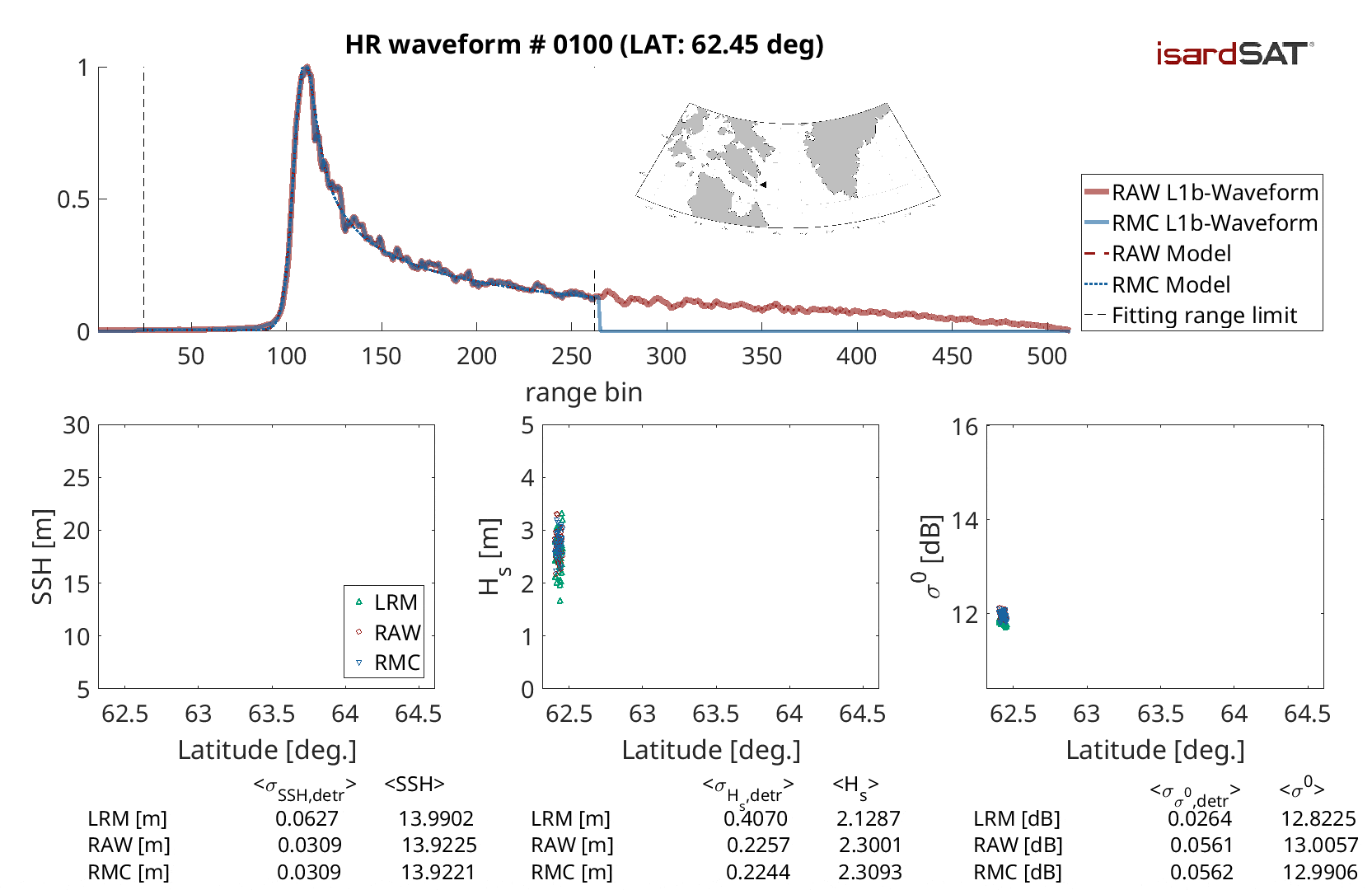
On the top: Comparison of SAR-RMC data (blue) and SAR-RAW data (red). SAR-RMC data is the normalised data processed on board of the satellite and downlinked. In this case, the trailing edge of the data on the right side of the waveform is removed before being transmitted to Earth, in order to reduce the weight of the data 50% so it is easier to process. On the other hand, SAR-RAW data is the full raw data processed directly on the ground.
On the bottom: The geophysical parameters Sea Surface Height (SSH), Significant Wave Height (Hs), and sigma-0 (s0), which have been derived using isardSAT’s L2 processor are compared in three different modes: Low Resolution, SAR-RAW, and SAR-RMC. The results show low levels of noise and inappreciable or minor biases.
Instrument calibration
As with Sentinel-6A, isardSAT is responsible for the internal in-flight calibration monitoring of the Sentinel-6B satellite, as well as for its absolute calibration and other validation activities. Instrument calibration plays a key role in satellite data processing, ensuring the accurate retrieval of altimeter scientific measurements.

An initial analysis of Sentinel-6B calibration data focuses on the early evolution of the internal time delay, instrument echo power, and system resolution (PTR width), together with an assessment of internal system distortions.
All parameters meet the mission requirements. As expected, notable calibration changes occur during the commissioning phase at the beginning of the mission. For Sentinel-6B, a clear improvement in system power performance is observed, avoiding the strong power decay seen during the first weeks of previous Copernicus altimetry missions.
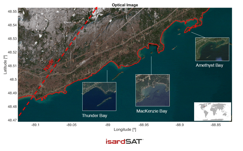
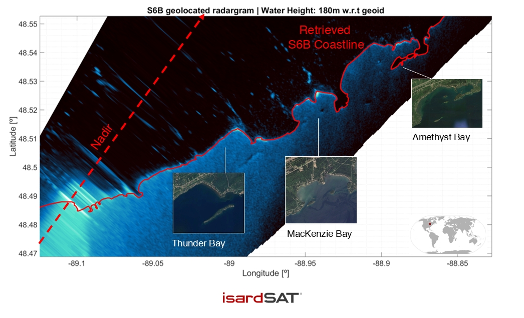
Fully-Focussed SAR processing on Sentinel-6B data
Sentinel-6B data processed with Fully-Focussed SAR is able to retrieve geophysical features of the Earth surface, such as the coastline. It can be seen on this pass over the Superior Lake (Canada).